How a smallholder cooperative and our export team assembled a complete, audit‑ready EUDR due diligence package in seven days using free tools. What we captured, how we mapped farms, the risk checks we ran, and the exact chain‑of‑custody documents buyers asked for.
Hook: we went from “no data” to an export‑ready EUDR dossier in 7 days using this exact system
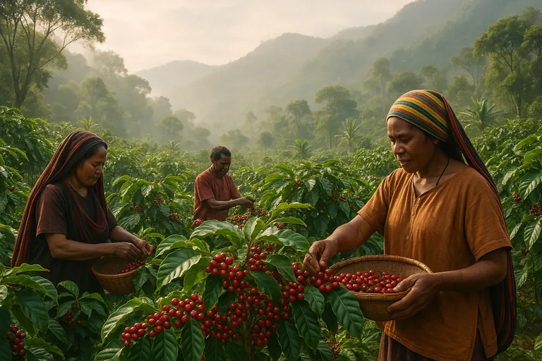
Here’s the situation. A smallholder cooperative in Bali brought us a 19.2‑ton container of Grade 1 Arabica destined for a European buyer. They had farmer names and purchase receipts. They did not have farm geolocation, risk checks, or a due diligence statement. We built a complete EUDR package in one week, got buyer sign‑off, and shipped. Below is the step‑by‑step, with the exact tools and templates.
We’ve repeated this workflow for North Sumatra shipments like Blue Batak Green Coffee Beans and Bali microlots like Arabica Bali Kintamani Grade 1 Green Coffee Beans. The playbook holds up across origins as long as you’re disciplined about IDs, coordinates, and documentation.
The 3 pillars of fast, audit‑ready EUDR compliance
-
Geolocation that holds up. Clean farm IDs, accurate WGS84 coordinates, and a simple map that a buyer can read without a GIS degree.
-
Deforestation‑free verification. Evidence that plots weren’t deforested after 31 Dec 2020. We use satellite layers and a repeatable risk assessment methodology.
-
Chain‑of‑custody continuity. Every kilogram traceable from farmer purchase through cooperative aggregation to export lot, with lot codes on every bag and matching documents.
Get those three right and the EU due diligence statement is an upload, not a panic.
Day 1–2: mapping and validation (tools + templates)
We started with 142 farmers supplying the lot. Our goal for Day 2: capture coordinates for 100% of plots, validate accuracy on a sample, and assemble a master farmer table.
-
Field data capture. We used KoboCollect/ODK with a simple form: Farmer ID, Name, Village, Consent checkbox, GPS point capture, Farm size (ha), Main species, Intercrops, First planting year. Offline works fine.
-
Free mapping tools. QField on Android or QGIS desktop for polygon sketching. For points, we double‑checked in Google Earth. If you prefer, MapIt GIS and Maps.me work offline too.
-
Accuracy checks. We turned on accuracy/HDOP fields in the form. Anything with reported accuracy worse than 15 m was re‑captured. In our experience, you get <5 m accuracy if you pause 10–20 seconds on site.
-
Farmer consent. We never skip it. A one‑page consent form in Bahasa Indonesia plus signature or thumbprint, referencing data use for EUDR. We store a photo in the record.
Practical takeaway: name your Farmer IDs before you go. We use three letters for the village plus a four‑digit sequence, like ULI‑0043. It saves hours later.
What geolocation format does the EU accept for coffee farms?
Use WGS84 latitude/longitude in decimal degrees. For polygons, list vertices in order and close the shape by repeating the first point at the end. For points, one coordinate pair.
Do I need full farm polygons or are point coordinates enough for coffee?
The regulation requires geolocation of the plots of land. Polygons are the cleanest way to prove what’s inside the farm boundary. In practice, many buyers accept a single point per smallholder plot if polygons aren’t feasible during the first season, but they’ll still flag higher risk. Our rule: capture points now, and upgrade to polygons for repeat suppliers within one harvest. If you can draw polygons in QField while you’re there, do it.
Day 3–4: deforestation‑free verification and risk assessment
Here’s the thing. Buyers don’t want a pretty map, they want to see your logic. We used a simple, defensible method that we can replicate shipment after shipment.
-
Global Forest Watch. We loaded the farm coordinates into GFW and checked tree cover loss layers post‑2020. We noted any GLAD alerts near plots in the last 24 months.
-
Indonesian layers. We overlaid the latest land cover map and peat/protected area references from KLHK and the forest moratorium map (PIPPIB). Farms inside protected areas trigger a mitigation plan.
-
Buffer checks. For polygons we used a 30 m inward buffer to be conservative. For points we placed a 50 m radius and assessed recent changes in high‑resolution satellite imagery.
-
Risk scoring. Low risk: no alerts or loss nearby, not in protected zones, previous harvest history pre‑2020. Medium risk: alerts within 100 m or unclear tenure. High risk: overlap with protected areas or obvious post‑2020 clearing.
-
Mitigation. For medium/high risk we required additional evidence. Photos of old trees, farmer affidavit of planting year, neighbors’ statements, or village letters confirming long‑standing coffee. We excluded two plots on Day 4 because imagery showed fresh clearing after 2021.
How can a cooperative prove coffee wasn’t sourced from land deforested after 2020?
Use a stack of evidence. Satellite imagery time series, GFW alerts, planting year data, and internal inspection notes with photos of mature trees. Where tenure is informal, add village letters. If there’s doubt, exclude the plot. Removing 1–2 borderline farms is faster than debating with an auditor later.
Day 5: chain of custody that actually links to your farms
Traceability breaks when purchase records don’t reference farms. We’ve found the simplest system wins.
-
Link purchase to Farm ID. Every parchment purchase receipt includes Farmer ID, date, weight, and moisture. We typed this directly into the master table.
-
Lot coding. We created an export lot code in this format: BLI‑2024‑WK37‑L01. It’s printed on every bag and appears in the drying, hulling, and grading logs.
-
Aggregation limits. We capped to 50 farms per lot for this shipment. There’s no legal limit, but documents get messy over 80–100. If you’re shipping blends like Bali, Java, Gayo & Mandheling - Wine Green Arabica Coffee Beans, keep regional lots separate until final blending inside the same EUDR statement.
-
Packaging and coding. Each bag carries a QR code with Lot code, Bag number, Net weight, and a link to a read‑only lot sheet. Low tech works too. Printed labels plus a binder at the mill.
How do we link farmer plots to lots and export invoices for EUDR traceability?
Use one master spreadsheet. Tabs for Farms, Purchases, Processing, Lots, and Shipment. The Lot tab summarizes farms and volumes that flow into each lot. Your invoice references the Lot code, and your due diligence upload references the same Lot code with farm coordinates.
Day 6: compile an auditor‑ready dossier buyers actually like
We’ve learned to package data the way auditors read it.
-
A one‑page summary. Origin, number of farms, area, methods, data tools, and the risk result.
-
A map PDF. Simple overview with village boundaries and plot locations. No GIS jargon.
-
The farm table. CSV with Farmer ID, coordinates, area, species, planting year, and consent status. Clean headers. WGS84 decimals.
-
The risk memo. Two pages that explain your datasets, buffer distances, and mitigation steps. Screenshots of GFW where it matters.
-
Supporting docs. Sample consent forms, internal inspection checklists, purchase receipts, and the lot coding SOP.
What documents should we collect from smallholder farmers for EUDR compliance?
At minimum: consent form, farmer ID proof, farm location and size, planting year, species, and an internal inspection checklist with photos. Add land tenure evidence if available. Keep everything tied to the Farmer ID.
Day 7: submit to the EU due diligence statement portal and close the loop
The EU’s due diligence statement portal accepts a structured submission with geolocation and supply chain data. We uploaded our CSV, attached the risk memo and map, and referenced the Lot code in the commercial invoice and packing list. The buyer reviewed the same bundle. No surprises.
Pro tip: run a dry‑run export of your CSV from day one and validate column names. Last‑minute formatting is where most submissions stumble.
If you want a quick sanity check on your dataset before you submit, you can Contact us on whatsapp. We’re happy to look at your headers and mapping approach.
The questions we get all the time
Which free apps can field staff use to capture GPS and farm data offline?
KoboCollect/ODK for forms, QField for polygons, Maps.me or MapIt GIS for quick points. Google Earth for desktop validation. All work offline with a bit of setup.
How many farms per lot should we aim for?
We aim for 30–50 farms per lot for smallholders. Bigger than that is fine, but reviews take longer and errors creep in. For single‑origin lots like Sumatra Mandheling Green Coffee Beans, we often keep sub‑lots by village to simplify.
How often should we update farm geolocation and risk assessments?
Annually for repeat suppliers, and immediately when a farm boundary changes or you add new farmers. Risk checks should run each shipment cycle because GFW alerts update weekly.
Validating GPS accuracy for smallholder coffee plots
Capture at least two points per farm visit and compare. Flag anything with accuracy worse than 15 m for re‑visit. Cross‑check against high‑res satellite imagery around obvious features like roads and river bends.
Sample data fields for an EUDR submission
FarmerID, Name, Village, Latitude, Longitude (or Polygon), FarmAreaHa, PlantingYear, Species, Consent, PurchaseDate, ParchmentKg, LotCode.
The 5 biggest mistakes that kill EUDR submissions
-
No consent or messy IDs. If Farmer IDs change mid‑season, your chain of custody breaks.
-
Pretty maps with no method. Auditors need to see the datasets and thresholds you used, not just pins on a map.
-
Mixing regions too early. Keep district lots separate until you finalize your statement. Blend later if needed.
-
Weak evidence near protected zones. If plots sit close to a reserve, stack proof. Photos, letters, planting years.
-
Leaving packaging out. Lot codes must appear on bags, warehouse logs, and the invoice. That continuity is your safety net.
Resources and next steps
-
Free mapping stack: ODK/Kobo, QField, QGIS, Google Earth, Global Forest Watch.
-
Internal templates to copy: farmer consent, internal inspection checklist, risk memo outline, and lot coding SOP. If you need examples, View our products and request the template set when you sample an origin.
-
When this advice applies. Smallholder Arabica and Robusta from Indonesia’s main origins, cooperative or collector‑based supply. If you’re running estates with cadastral maps, go polygon‑first and tie your GIS export directly to your ERP.
The reality is EUDR isn’t going away, and in the last six months we’ve seen European buyers tighten expectations on polygons and narrative risk memos. Do the work once. Save the structure. Each new shipment becomes a fast update, not a reinvention.
And if you want to walk through this process on a live lot from Bali, Aceh, or Sumatra, we’re here. We can pair your team with ours on a one‑week sprint and hand back a package your buyer will sign on first pass.